
West Fork Fire: Five years after


VALLEY—The West Fork Complex Fire burned 109,000 acres in south-central Colorado in 2013. This galvanizing event brought together local stakeholders and federal and state agencies to address collaboratively the post-disaster issues facing rural communities.
RWEACT (Rio Grande Watershed Emergency Action Coordination Team) was formed during the fire to promote partnerships and actions that provide for public safety and resiliency of communities and watersheds of the Rio Grande Basin of Colorado. RWEACT focuses on common goals of public safety, preparedness and communication; economic stabilization and recovery during and after a disaster; reducing post-fire impacts with natural resources and increasing resiliency for communities and the Upper Rio Grande watershed.
“We have not been hindered by jurisdictional authorities, but rather strengthened knowing that if one of us can’t do what we hope, it is likely another entity can,” said Dan Dallas, forest supervisor of the Rio Grande National Forest, during an early planning meeting. This approach to partnership has proved successful in the region.
In July of 2013, an advisory board with representatives from each of the three disaster area counties (Hinsdale, Mineral, Rio Grande) was formed. Committee leaders for five programs of work were identified – natural resources (led by a regional nonprofit natural resource organization); hydrology (led by a hydrologist familiar with the region); communication (operated by committee of public information specialists); economic recovery (led by a regional nonprofit economic development group) and emergency managers (led by a participating county emergency services manager). Each of these committees created a short-term plan for work needed during July, August, September 2013 to address immediate needs and has since transformed into more long-term strategies and actions. A name, logo, staff, and list of action items were reality within two days of the concept of RWEACT.
Overall actions by the natural resources committee have included pre-BAER work together with public lands representatives to identify values at risk based on local landscape knowledge; an Upper Rio Grande assessment to guide/prioritize projects needed for resiliency and restoration of watershed health; a water quality study over the four-year post-fire period; a USGS potential debris flow mapping project; consultation with impacted private homes and businesses (resorts); installation of six Test Plots and the ongoing monitoring with varying actions for restoration taken per site; a Boreal Toad project and installation of hard-bottomed boat ramps to reduce siltation in the river and increase boating tourism in the region.
Overall actions by the hydrology committee have included the coordination of instrumentation throughout the region to monitor post-disaster conditions with regards to rainfall and stream flow and included work with the RAWS, installation of new stream gauges and rain gauges, including a stream gauge located upstream of Little Squaw Resort with an alarm system that would allow a nine-minute notice for evacuation if a debris flow blocked the drainage above. Instruments have been relocated based on need and monitoring data is available. The rain and stream gauge instruments transmit real-time data electronically to a website and are monitored by the National Weather Service staff in Pueblo and Grand Junction who can issue a weather watches, warnings and advisories.
Overall actions by the economic recovery committee included a post-disaster economic recovery study that identified the following goals: support existing, local businesses in each community; increase regional marketing in a collaborative way; increase opportunities for regional heritage tourism in a collaborative way; increase commercial opportunities for outdoor recreation related to public lands and study feasibility/opportunities for a biomass industry. Projects have included signage, smart phone applications, collaborative partnership at trade shows for tourism and marketing, a regional shop local program, planning efforts together with existing needs per community (this included a business retention plan and master recreation plan for Lake City, updates to community plans for South Fork, Del Norte and Monte Vista, a downtown assessment for Creede), an evaluation of lodging tax and sales tax to determine recovery rates and multiple forestry studies (one published) conducted to determine availability and merchantability. The have also been several studies determining economic impacts of wildfire.
Overall actions taken by the communications committee included coordinating messages throughout the region for public health hazards, road closures and marketing messages to minimize impacts on tourism; consistent messaging focuses on “Move Up, Not Out” (for post-fire flooding impacts); safety within burn scar areas and recovery efforts; trainings held with partners to improve collaboration during an event. Methods have included websites, social media, rack cards, advertising, press releases, brochures, signage, public meetings, community workshops and training events such as FEMA’s working with the media class, media article generation and video vignettes.
Overall actions taken by the emergency managers committee included developing a Three-County Early Notification Plan & Protocol bringing together all entities and addressing actions on a geographical region; installing temporary Doppler radar in 2013, 2014, and 2015 during the monsoon season to increase notification together with the National Weather Service; distributing weather radios and hosting weather spotter training; installing or improving VHF and Ham radio communications throughout the region; purchasing an unmanned drone for reconnaissance and evaluation of hazards; outfitting of an ICS mobile command center and hosting regional trainings, tabletop exercises, and scenarios with all partners; necessary trunk radios for counties; new batteries for the Hill 71 communication site; and FEMA flood insurance trainings.
Partners included federal, state, and regional agencies; local governments (counties, municipalities, health departments, sheriff’s offices); nonprofit organizations (natural resource nonprofits, chambers of commerce, Main Street programs, public health nonprofits); businesses; residents and media representatives. More than 70 partners have implemented 200 projects or initiatives with RWEACT in the last five years.
Funding sources overseen by RWEACT
Executive Order 2013-017 for $195,000 through Office of Emergency Management for economic recovery (received by Rio Grande County on behalf of four counties – Hinsdale, Mineral, Rio Grande, Archuleta
Executive Order 2013-022 for $2.5 million through the Colorado Water Conservation Board for natural resource impacts and emergency notification and communication (received by Hinsdale County on behalf of Hinsdale, Mineral, Rio Grande
Department of Local Affairs grant for $100,000 (received by Rio Grande County on behalf of four counties (Archuleta, Hinsdale, Mineral, Rio Grande) for economic recovery actions
Energy Impact grant #8056 for $118,000 to increase the geographical area of RWEACT, develop stewardship agreements, and work together with the Rio Grande National Forest on the Forest Plan Revision (received by Rio Grande County on behalf of the seven-county region)
So what and now what?
Five Years Later, RWEACT is both reflecting on what has been accomplished and the bigger questions of “So What?” and “Now What?” The legacy of RWEACT is found in its 3 Rs:
Increased Resiliency of Communities and Watersheds & Action Plans to Continue this Work
Regional Connection & Intentional Collaboration
Permanent Radar at the Alamosa Airport
Together with the Colorado Department of Transportation (CDOT) and the Colorado Water Conservation Board (CWCB), the water community, and many other partners, RWEACT anticipates installation of radar by December of 2018 to increase public safety for notification of weather, improve stream forecasting, and allow for consistent air travel to the San Luis Valley which impacts tourism and commercial work. They have expanded their geographical focus and board of directors from three West Fork Complex fire disaster-impacted counties to seven watershed-wide counties (Alamosa, Conejos, Costilla, Hinsdale, Mineral, Rio Grande, Saguache) and received 501(c)(3) status. The group is working to secure grant funds for prioritized projects identified in the Upper Rio Grande Watershed Assessment and the Post-Disaster Economic Recovery Plan.
For more information, please contact Kristine Borchers, program manager, RWEACT, 970-596-9071 or [email protected]
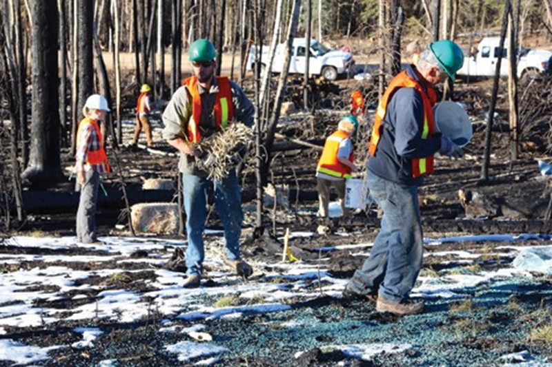
Caption: Following the fire, volunteers worked in test plots within the burn scar to see what type of plants would grow in place of the high alpine forests and continue to do so today./Courtesy photo